Latitude and Longitude
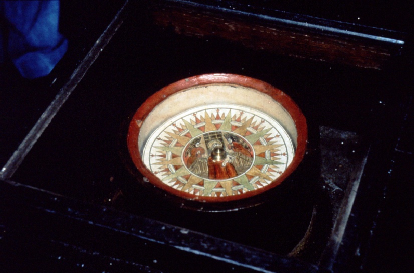
VISUAL 22 (still): Box Compass
Columbus used a compass like this one, which he adjusted by the North Star just as we did a little while ago in China. Columbus also used a device known as a quadrant to find his latitude from the North Star.
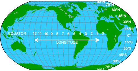
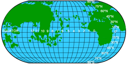
VISUAL 20 (still): Modern World Map with Latitude and Longitude Shown
DIGITAL EFFECT: Scale Down and Fade
Scale down and then fade off the box compass image.
Latitude is distance north or south of the equator measured in degrees. [Point this out on the map.]
Longitude is the distance east or west from the Greenwich Meridian.
The Greenwich Meridian is an imaginary line that goes from pole to pole through the city of Greenwich, England, and several European countries including Spain. Longitude can be measured in degrees, or in time zones as we see here. [Point this out on the map.]
A quadrant is a quarter of a circle. It is also the name of a navigational instrument that is shaped like a quarter of a circle, and marked in degrees. A whole circle has 360 degrees. A quarter of a circle, a quadrant, has 90 degrees. You can now use your quadrant to measure the angle between the North Star and the horizon.
[Fade off the map.]
Distribute quadrants and explain how to hold them, sighting along the top edge. Explain that you use your free hand to “clamp” the pointer onto the scale on the quadrant, and then read the degrees on the scale. To help the students sight on the North Star, turn on the arrow that indicates the celestial North Pole.Arabic and Chinese navigators also used tools similar to the quadrant used by Columbus.
Imagine you are at the North Pole and must look straight up to see the North Star. What would the reading on your quadrant be at the North Pole? Try it! [90°.]
As you can see on your map, 90° is also the latitude of the North Pole. Now imagine you are at the equator where you would see the North Star on the horizon.
What would your quadrant read there? [0°.]
Actually, Polaris is just under 1° from the true North Pole. Mariners have long known how to correct for this error, but it is probably too small to notice in the planetarium.
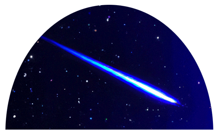
DIGITAL EFFECT: Use Quadrant
Highlight Polaris. Use as a reference for using a quadrant.0° is the latitude of the equator. In between the equator and the North Pole, the height of the North Star will be in between 0° and 90° and the number of degrees is the same as our latitude.
Can we still find the North Star? [Point it out.]
Imagine that each of you, by sitting in a different place in the planetarium, are in a different location in the world Columbus knew well, either Europe or Africa.
Alternatively, have students pretend that they are somewhere in the Americas.
Now, let’s all measure the altitude of the North Star.
DIGITAL EFFECT: Meridian On
Fade on the meridian. Use to indicate what a quadrant helps measure (i.e., height of Polaris above the horizon).

Allow students to report their measurements. Tell different groups of students what country they would be in for their particular measurement:
Raise your hand if your reading was between 60° and 70°.
60°–70° Norway (or Alaska)
50°–60° England (or Canada)
42°–50° France (Oregon or Washington)
36°–44° Spain, Italy (or California)
0°–36° Africa (Southern California: 32°–36°),
(Mexico: 16°–32°), (Central America: 7°–16°)
Please find Spain on your “Columbus’ World Map.” What is the latitude of Spain?
[Anywhere from 35° to 44° shows that your students are reading the map correctly.]
DIGITAL EFFECT: Unhighlight Polaris and fade off the meridian.

DIGITAL EFFECT: Columbus Voyage
Crossfades the scene to today, noon at the coordinates of Cadiz, Spain, where Columbus began his fourth voyage. All realtime effects, except the sky, are off. The ocean sound file is loaded and faded up to play.
Optional
Ask if anyone can explain the differences. (In the planetarium, we are not measuring the real North Star. If you go out at night to sight the real North Star, all your measurements would be very close to the same number. This is because the real North Star is extremely distant.)
In 1492, Columbus set sail from southern Spain which is about 36° north latitude.
DIGITAL EFFECT: Highlight Polaris
Highlight Polaris to record the current latitude.
Please record the latitude of Spain as 36° N at the bottom of the page.
DIGITAL EFFECT: Unhighlight Polaris
First, he sailed south to the Canary Islands. As we sail south, days and nights and days go by.
[Play ocean sounds.]
DIGITAL EFFECT: Go to Canary Islands
Move latitude to about 28° N for the Canary Islands, at local noon, over 15 seconds. During the “travel time,” fade the atmosphere on (over 2 seconds) and off (over 2 seconds) three times to simulate the passage of time over many days—even though no time is actually changing. Use a 4 second delay between the fade down and the following fade up of the atmosphere so the stars are visible for more of the “trip.”

DIGITAL EFFECT: Highlight Polaris
Highlight Polaris to record the current latitude.
Please measure the altitude of the North Star again and tell me if it is higher or lower in the sky?
[Lower; we are farther south than Spain.]
DIGITAL EFFECT: Unhighlight Polaris

If your students are concerned that their measurements are all different from each other’s, tell them that it is because they are not measuring the real North Star. The one in the planetarium is much too close. They should all agree, however, on whether or not the North Star is higher or lower than before.

Identify a student or group of students whose measurement was close to 28°.

At the Canary Islands Columbus measured the altitude of the North Star to be about 28° above the horizon, just as these students.
Let’s record at the bottom of the page the latitude of the Canary Islands as 28° north.
From the Canary Islands, near Africa, Columbus sailed west across the great Ocean Sea.
[Ocean sounds.]
DIGITAL EFFECT: Go To Mystery Island
Travel to the coordinates of Jamaica, about 18° north, at local noon, over 30 seconds. During the “travel time,” fade the atmosphere on (over 2 seconds) and off (over 2 seconds) five times to simulate the passage of time over many days—even though no time is actually changing. Use a 4 second delay between the fade down and the following fade up of the atmosphere so the stars are visible for most of the “trip.”

Fade off ocean sounds.
When they finally arrived at an island in what they thought were the Indies, Columbus and his men were treated very well by the native people, called Tainos or Arawaks. Yet Columbus later forced these people to provide him with gold. He enslaved and killed many of those who had previously helped him.
VISUAL 23 (still): Brutality
[Fade on the still image of Brutality.]

[Fade off the brutality image.]
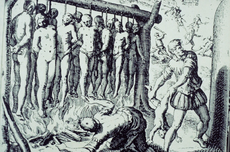
This brutality was reported by some of Columbus’ Spanish countrymen who felt that what Columbus did was wrong. This drawing was done by a Spanish priest named Bartolomé de Las Casas. It is based on what he saw on Hispaniola, the large island where Columbus built the first Spanish colony. Friar de Las Casas spent most of his life trying to stop the enslavement and murder of the Native Americans. Many textbooks have ignored this bit of history.
Columbus made four journeys to the Americas. On his third journey he was stranded for over a year on an island that we shall call Mystery Island. Let’s see if we can figure out exactly where Columbus was.
DIGITAL EFFECT: Measure Latitude
Highlight Polaris to record the current latitude.
Please measure the altitude of the North Star again and tell me if it is higher or lower in the sky.
Identify a student or group of students whose measurement was close to 18°, and announce that they got the same measurement as Columbus did on the mystery island.

DIGITAL EFFECT: Unhighlight Polaris
Please look again at your “Columbus’ World Map.” Write the latitude of the mystery island: 18° N.
But how could Columbus tell how far west of Spain he was? Columbus estimated how far west he was by observing an eclipse of the Moon.
In order to understand how a lunar eclipse helped Columbus determine his longitude, you need to understand that people separated by large east-west distances see an event (such as an eclipse) at different times of day.
Optional
Have everyone stand up. Tell people in the east part of the planetarium that they are in New York. People in the west part of the planetarium are in California. People in between are in mountain or midwest states (like Kansas).

DIGITAL EFFECT: Sunrise To Noon
Crossfade the scene to go to about one hour before sunrise today. Turn on the Sun and atmosphere, to get ready to go through a full day.

Tell the student that you are speeding up time. Begin diurnal motion and have them watch the stars move until sunrise. Explain that during the day, the Sun will not go straight overhead, but will sweep in a curved path towards the south.

DIGITAL EFFECT: Go To Evening

Fast forward to about one hour past sunset today over 50 seconds. After a 47 second pause, fade off the atmosphere.
Continue diurnal movement, and have people call out “noon” when the Sun is most directly over them.

Did everyone say “noon” at the same time? [No.]

Do people in California see the noontime Sun at the same time as people in New York? [No, Californians see the noon-time Sun about 3 hours after New Yorkers do.]

How about Spain? [Even more time difference.]
Have you ever talked on the telephone to a friend or relative in a different time zone and asked them what time it was there? “How many time zones between New York and San Francisco?”
[3 hours apart.]
Suppose you were to pick up the telephone in San Francisco, California, and call Spain. If it is 12:00 noon in the San Francisco Bay Area, the person in Spain says it is 8:00 p.m.
How many time zones are you west of Spain?
[8 in Berkeley. Use the difference for your location.]
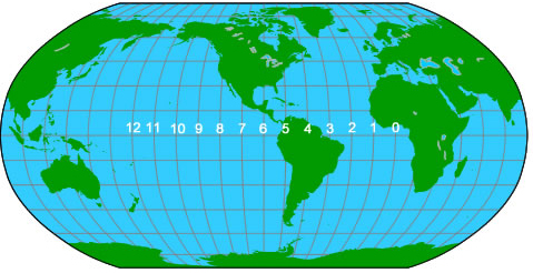
Check it out on the “Modern World Map.”
VISUAL 24 (still): Modern World Map with hours marked on equator
DIGITAL EFFECT (optional): Relocate Image
Relocate the Modern World Map Image to due south.
[Point to map to illustrate what the students are looking for on their maps.]
Please look at your papers of the two world maps again.
Notice the numbers along the equator. They are time zones. Altogether, the world is divided into 24 time zones just like the 24 hours in a day, one hour for each time zone.
[Fade off map image.]
DIGITAL EFFECT (optional): Relocate Map Image
After the map image fades, relocate the image to the southwest.
How many of you have seen an eclipse of the Moon?
[Take a show of hands.]
Let’s watch the eclipse from the beach where Columbus landed.
DIGITAL EFFECT: Lunar Eclipse
Crossfade the scene to 1504/02/29 at the coordinates of Jamaica as the partial lunar eclipse is starting. To show proper timing and alignment of the eclipse, scale the Sun and the Moon to size = 1x. If possible, add show a “telescopic view” of the eclipse (e.g., a movie or additional dome camera). Highlight the Moon so it can be easily spotted in the sky. Display the planetarium clock and the position information on the dome.

DIGITAL EFFECT: Run Eclipse
Run diurnal motion forward approximately 4 hours, until 30 minutes past the end of the partial eclipse phase, over 40 seconds.
Columbus records in his journal that he timed the ending of the eclipse to determine how far around the world he had traveled from Spain. Let’s see how he did that, and how we can determine where in the world the mystery island is located.
When you see the eclipse end, say “Now” out loud.
[Students say “Now” at different times as the eclipse ends.]
We each saw the eclipse end at a little different time. It is hard to determine the exact time when an eclipse ends.
Columbus, on the mystery island, watched the same eclipse that the people in Spain watched. But the local time of night was earlier for Columbus than for the people in Spain. The time difference could tell Columbus how far west of Spain he was. Let’s see how far west he thought he was.
Columbus recorded the time of an eclipse that people in Spain were also watching. Comparing his time record with those of his friends in Spain, he could find out how many time zones away from Spain he had traveled.
Do you think that Columbus just timed the lunar eclipse with a stopwatch and then telephoned his friends in Spain to ask them exactly what time their clocks said the eclipse ended in Spain?
[No. There were no stopwatches or telephones in Columbus’ day.]
DIGITAL EFFECT: End Eclipse
If necessary, fade off the “telescopic view” of the eclipse, and fade off any highlights on objects. Turn off the planetarium clock and the position information. Fade off the Sun and Moon, and also resize them to their default sizes if necessary. Note: The Lawrence Hall of Science resizes the Sun and Moon to size = 5x. Users should create their own  “Sun/Moon Resize” function to resize the Sun and Moon to their own theater’s default size.
Columbus used big sand clocks, like giant egg timers, to measure the passage of hours. It was very difficult to determine exactly when an eclipse ended.
Columbus saw the eclipse end about 2 hours after sunset. He had a book that predicted the end of the eclipse would be seen in Spain 7 hours after sunset.
What is the time difference between Spain and the mystery island? [5 hours.]
The mystery island is about 5 time zones west of Spain.
VISUAL 19 (still): Columbus’ World Map
Let’s see where that is on Columbus’ World Map. First, let’s count off the five hours west. Count with a pointer.
Now, what is the latitude we measured earlier for the mystery island?
[That’s 18° north of the equator.]
So, where in the world was Columbus?
[Point on projected map.]
About here, near the part of the world he thought was the Indies.
VISUAL 20 (still): Modern World Map
Now, let’s count off 5 time zones, and find out where Columbus was on the Modern World Map. Also, remember that his latitude was 18° North.
Does anyone know the name of the islands here?
[Point to visual.]
The small one where Columbus landed is Jamaica. The mystery island is really Jamaica!
DIGITAL EFFECT: End Map
Fade off both map images.
Columbus returned to Spain believing that the islands he explored were very close to the Indies. This was because he had incorrect ideas about the size of the Earth and how much was covered by land versus ocean. He never visited the land we call North America.